According to new research, global warming has caused extreme ice melting events in Greenland to become more frequent and intense over the last 40 years, rising sea levels and flood risk globally. Over the last decade, 3.5 trillion tonnes of ice have melted from the island’s surface and flowed downhill into the ocean. That’s enough melted ice to cover the entire United Kingdom with approximately 15 metres of meltwater or approximately 4500 metres to cover the entire City of New York.
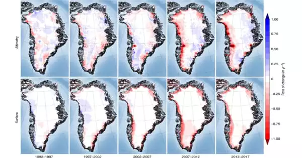
The new research, led by the University of Leeds, is the first to use satellite data to detect this phenomenon from space, known as ice sheet runoff. The findings, published in Nature Communications, show that meltwater runoff in Greenland has increased by 21% over the last four decades and has become 60% more erratic from one summer to the next.
Dr. Thomas Slater, lead author and Research Fellow at the University of Leeds’ Centre for Polar Observation and Modelling, stated: “Greenland, like other parts of the world, is vulnerable to an increase in extreme weather events. As our climate warms, it’s reasonable to expect more instances of extreme melting in Greenland – observations like these are critical in helping us improve climate models and better predict what will happen this century.”
Greenland is vulnerable to an increase in extreme weather events. As our climate warms, it’s reasonable to expect more instances of extreme melting in Greenland, observations like these are critical in helping us improve climate models and better predict what will happen this century.
Dr. Thomas Slater
The European Space Agency’s (ESA) Polar+ Surface Mass Balance Feasibility project funded the study, which used measurements from the ESA’s CryoSat-2 satellite mission. According to the study, increased meltwater runoff from Greenland raised global sea level by one centimetre over the last decade (2011 to 2020). One-third of this total was produced in just two hot summers (2012 and 2019), when extreme weather caused unprecedented ice melting levels not seen in the previous 40 years.
Rising sea levels due to ice melt increase the risk of flooding for coastal communities around the world and disrupt marine ecosystems in the Arctic Ocean that indigenous communities rely on for food. It can also change ocean and atmospheric circulation patterns, affecting weather patterns all over the world.
Greenland runoff has averaged 357 billion tonnes per year over the last decade, with a peak of 527 billion tonnes of ice melt in 2012, when changes in atmospheric patterns caused unusually warm air to sit over much of the ice sheet. This was more than double the minimum runoff of 247 billion tonnes in 2017.
The changes are related to extreme weather events, such as heatwaves, which have become more common and are now a major cause of ice loss from Greenland due to the runoff they produce.
According to Dr. Slater: “There are, however, reasons to be optimistic. We know that setting and meeting meaningful emission-cutting targets could reduce ice loss from Greenland by a factor of three, and there is still time to do so.”
These first space-based observations of Greenland runoff can also be used to validate how climate models simulate ice sheet melting, allowing for better predictions of how much Greenland will raise global sea levels in the future as extreme weather events become more common.
Dr Amber Leeson, Senior Lecturer in Environmental Data Science at Lancaster University and study co-author, stated: “According to model projections, the Greenland ice sheet will contribute between 3 and 23 cm to global sea level rise by 2100. The uncertainty associated with simulating complex ice melt processes, including those associated with extreme weather, contributes to the wide range of this prediction. These new spaceborne runoff estimates will help us better understand these complex ice melt processes, improve our ability to model them, and, as a result, allow us to refine our estimates of future sea level rise.”
Finally, the study demonstrates that satellites can provide instant estimates of summer ice melting, which supports efforts to increase Greenland’s hydropower capacity as well as Europe’s ambition to launch the CRISTAL mission to replace CryoSat-2.
ESA’s CryoSat mission manager, Tommaso Parrinello, said: “CryoSat has yielded a wealth of information about our rapidly changing polar regions since it was launched over 11 years ago. This remarkable satellite continues to be critical to scientific research and the undeniable facts, such as these findings on meltwater runoff, that are so important in making decisions about the health of our planet. Looking ahead, the Copernicus Sentinel Expansion mission CRISTAL will ensure that Earth’s vulnerable ice is monitored over the next several decades. Meanwhile, it is critical that CryoSat remain in orbit for as long as possible in order to close the gap before these new Copernicus missions become operational.”


