High-tech pavement markers are undoubtedly vital in assisting autonomous driving, particularly in difficult conditions and remote places. These advanced markers employ a variety of technologies to improve road visibility and provide crucial information to autonomous vehicles, allowing them to operate more safely.
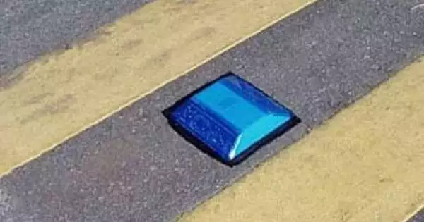
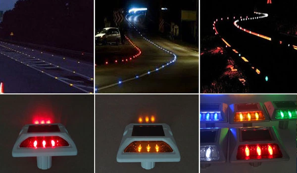
Engineers are embedding low-power sensors in reflective raised pavement signs, which are already used to assist drivers in identifying lanes. Microchips inside the markers convey information about the road shape to passing cars, allowing autonomous driving features to function even when vehicle cameras or remote laser sensing, known as LiDAR, are unreliable due to fog, snow, glare, or other impediments.
The road to reliability for self-driving electric vehicles remains hard. Researchers at the Department of Energy’s Oak Ridge National Laboratory and Western Michigan University are collaborating to develop solutions from outside the car, such as sensors and processing integrated in road infrastructure.
ORNL engineers are collaborating with partners to embed low-power sensors in reflective raised pavement signs that are already used to help drivers identify lanes. According to an article published in IEEE Sensors by ORNL researcher Ali Ekti and lead author Sachin Sharma of WMU, microchips inside the markings convey information about the road shape to passing cars. They are useful even when vehicle cameras or remote laser sensing, known as LiDAR, are rendered ineffective due to fog, snow, glare, or other impediments.
We are working to make autonomous driving features accurate and safe in more remote areas. And we are doing it by converting a dummy piece of infrastructure into something with many more uses.
Ali Ekti
“We are working to make autonomous driving features accurate and safe in more remote areas,” Ekti said. “And we are doing it by converting a dummy piece of infrastructure into something with many more uses.”
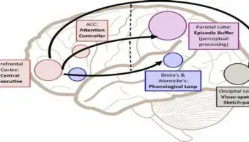
The technology not only provides more accurate information about the driving environment, but it also takes some of the processing load away from the car’s software and onto infrastructure. This conserves battery power in electric vehicles, prolonging driving range and encouraging more EV adoption. The chip-enabled pavement markers can cut navigational power consumption by up to 90% when compared to a leading camera and LiDAR-based autonomous driving technology, according to the authors of a technical article.
The technology has the potential to be used not only with self-driving vehicles of the future, but also with typical autonomous driving capabilities of today, such as lane assist.
The initiative is part of a larger effort led by WMU to develop related sensor and autonomous driving technologies such as radar retro-reflectors, high-definition mapping, computational offloading, and weather sensing. According to Zachary Asher, assistant professor of mechanical and aerospace engineering and director of the WMU Energy Efficient and Autonomous Vehicles Lab, WMU researchers are also using a vehicle driving on a closed course to measure the reduction in vehicle energy use enabled by these technologies.
ORNL researchers explored to identify the ideal transceiver, battery, and antenna combination for the sensor package inside regular road markings as well as those intended to endure snowplows. They then used a communications protocol that includes hopping across a specific radio frequency band 50 times per second. “It’s hard to detect, works well against interference, is low cost, and doesn’t consume a lot of power,” Ekti explained. Adjustments to the equipment might ensure that its battery lasted the same amount of time as the pavement markings, which is normally a year.
Ekti’s team created algorithms that triangulate among the GPS coordinates of lane markers to reconstruct an image of the drivable area. One algorithm is embedded in a microchip inside the pavement marker, while a decoding algorithm is incorporated into the car’s software.
ORNL researchers field-tested the sensor platform in a variety of weather conditions and in a remote national park in Montana with no wireless access. They found that it transmits more than five times beyond the original 100-meter goal.
“It’s amazing how far it can transmit — over hills, in snow. It’s a big deal,” Asher said. “Every step of the way, we’re surprised at how well this technology is working, and we’re finding some really cool ways it could be integrated.”
When high-definition maps are out of current, the sensors could potentially notify temporary lane adjustments or closures in construction zones. According to Ekti, marker sensors might potentially transmit information regarding temperature, humidity, and traffic volume. The project team intends to collaborate with students to create a smaller microprocessor for the markers as an alternative to more expensive off-the-shelf goods.
Asher is planning road demonstrations for stakeholders such as the Tennessee and Michigan transportation authorities, the Michigan Office of Future Mobility, and the City of Chattanooga. Asher explained that because these government organizations decide which technologies are adopted in infrastructure, their engagement in the development process is crucial.