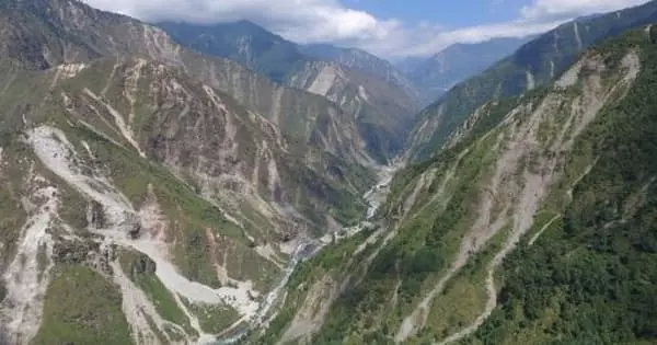
Strong earthquakes cause transient perturbations in the near-surface system of the Earth. These include widespread landslides and subsequent mass movement, as well as the sedimentation of rivers. Furthermore, during the event, the rock mass is shattered, resulting in cracks that affect rock strength and hydrological conductivity. These perturbations, which are frequently overlooked in the immediate aftermath of an earthquake, can represent a significant part of the overall disaster, with an impact that can last for years before returning to normalcy.
Researchers describe how they were able to establish a clear pattern between the strength of Nepal’s monsoon season and the amount of landsliding over a 30-year period between 1988 and 2018.
According to new research, earthquakes and extreme rainfall can cause a six-fold increase in the rates of rainfall-triggered landslides during Nepal’s monsoon season. Concerns were raised ahead of the 2016 monsoon season in Nepal that the destabilization of terrain conditions caused by the 2015 earthquakes could significantly increase the risk of landslides during monsoon rains, both in areas historically prone to landslides and flash floods and areas that have become susceptible as a result of the earthquakes.
Unfortunately, people in Nepal are frequently affected by landslides during the monsoon season, resulting in widespread damage to homes and infrastructure year after year. This study shows how much extreme rainfall and earthquakes can increase the risk of landslides, as well as how long those effects can be felt.
Josh Jones
Every year, severe landslides occur in the Himalayan nation as a result of the annual monsoon season, which lasts from June to August. However, a new study published in Nature Communications investigates how extreme rainfall and earthquakes can cause landslide rates that exceed those seen during a normal Himalaya monsoon season.
Researchers were able to establish a clear pattern between the strength of the monsoon season and the amount of landsliding by analyzing satellite imagery and rainfall data over a 30-year period between 1988 and 2018. This revealed that extreme “cloud outburst” storms in 1993 and 2002 caused roughly four times the number of landslides expected in an average monsoon season.
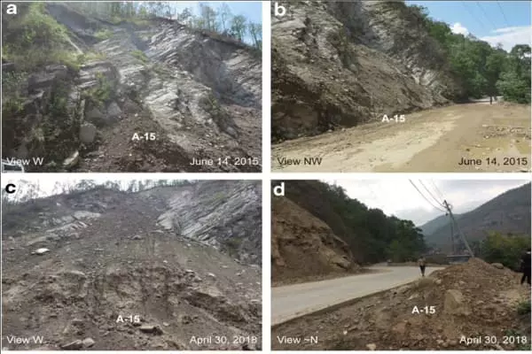
Similarly, the landscape damage caused by the April 2015 Gorkha earthquake was found to have caused roughly six times as many rainfall-triggered landslides as would be expected during the 2015 monsoon season. This landscape damage also increased the expected number of landslides during the 2016 monsoon season, with conditions returning to more normal levels by 2017.
The study also revealed that the most severe landscape damage caused by the 2015 earthquake occurred in nearby locations where high earthquake peak ground accelerations occurred across particularly steep mountain slopes, rather than at the epicentre itself.
Researchers from the University of East Anglia, the University of Plymouth, the University of Exeter, and the international engineering consultancy firm AECOM conducted the study.
The study’s lead author, PhD candidate Josh Jones, conducted the research while based in Plymouth and East Anglia. “Unfortunately, people in Nepal are frequently affected by landslides during the monsoon season, resulting in widespread damage to homes and infrastructure year after year,” he said. This study shows how much extreme rainfall and earthquakes can increase the risk of landslides, as well as how long those effects can be felt. We hope that this information will be useful in assisting local communities in planning for future landslide hazards, particularly after large earthquakes.”
“Once unusual rainfall and flood events are already becoming more frequent globally as a result of our changing climates,” said Dr Sarah Boulton, Associate Professor in Active and Neotectonics at the University of Plymouth. Climate models predict that Nepal will experience increased storminess and potentially higher annual rainfall levels in the future. According to our research, there have been two instances in the last 30 years where annual rainfall could be classified as extreme. Similar events could become more common in the coming years, causing even more devastation for the local populations.”
The research was made possible by the Environment East Doctoral Training Partnership (EnvEast DTP), which was supported by the Natural Environment Research Council (NERC) and AECOM CASE funding.
“This project demonstrates the benefits of collaborative work between industry and academia,” said Dr. Michael Whitworth, an associate director at AECOM. The findings of this study can help to reduce disaster risk in vulnerable areas, resulting in better planning and mitigation against landslide hazards caused by infrequent large events like earthquakes.”
Josh, a Postdoctoral Researcher at Exeter, spent eight months analyzing 30 years of satellite imagery to create a long-term picture of where landslides occur and the detailed effects they have on the landscape of central and eastern Nepal.
This was then mapped against monsoon, extreme rainfall, and earthquake data to provide a comprehensive picture of the major factors influencing increased landslide occurrences. As a result, an unprecedented inventory of Nepal’s landslides has been created, with just under 13,000 landslides recorded over a geographical area spanning more than 42,000km2 of the Himalayan region. It also depicts the geographical characteristics of areas most vulnerable to future landslides, as well as how extreme weather and large earthquakes may affect that risk.


