Researchers have deciphered perplexing patterns of sinking and rising soil in order to pinpoint the subsurface places where irrigation water is pumped.
Scientists have developed a novel technology that has the potential to improve groundwater management in dry areas, which is vital for both life and agriculture. The method distinguishes between underground water loss from aquifers enclosed in clay, which can be drained dry and never recover, and soil that is not confined to an aquifer, which can be restored by a few years of average rain.
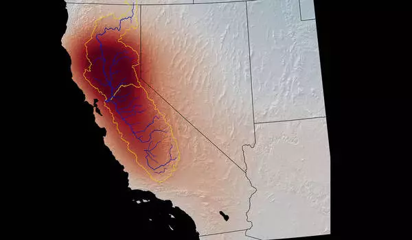
The Tulare Basin in California’s Central Valley was researched by the research team. The key to identifying these subsurface water sources, according to the study, is patterns of sinking and increasing ground levels in this extensively irrigated agricultural region.
The Central Valley accounts for only 1% of the total acreage in the United States, but it produces 40% of the country’s table fruits, vegetables, and nuts each year. That kind of output is only possible because farmers supplement the valley’s annual rainfall of 5 to 10 inches (12 to 25 cm) with significant groundwater pumping. During dry years, more than 80% of irrigation water comes from subsurface sources.
Underground water resources are depleting as a result of decades of pumping. To find appropriate water, wells in the Tulare Basin must now be sunk up to 3,500 feet (nearly 1,000 meters) deep. There is no way to know how much water remains beneath, so management must make the most use of what is available. This includes determining whether water is being extracted from aquifers or from loose soil, referred to as the water table. The only viable way to do so in this broad region with tens of thousands of unmetered wells is to use satellite data.
Credits: NASA/GSFC/SVS
NASA’s Jet Propulsion Laboratory in Southern California, as well as the U.S. The Department of Energy’s Lawrence Berkeley Laboratory in Northern California set out to develop a mechanism to accomplish this. They approached the challenge by integrating data on water loss from NASA’s GRACE and GRACE2. Follow-On satellites with data on ground-level changes from an ESA (European Space Agency) Sentinel-1 satellite. Earth-level changes in this region are frequently associated with water loss because when the ground is drained of water, it eventually slumps together and sinks into the voids where water once existed—a process known as subsidence.
The Tulare Basin is rapidly subsiding: The present rate of sinkage is roughly one foot (0.3 meters) each year. However, the ground may sink, rise, or remain constant from one month to the next. Furthermore, these changes do not always correspond to expected causes. The water table, for example, rises after a big storm. It appears logical that this would cause the ground level to rise as well, but it occasionally sinks instead.
The researchers reasoned that these inexplicable short-term fluctuations could contain the key to finding the sources of pumped water. “The big concern was how we interpret the change that’s happening on these shorter time scales: is it a blip, or is it significant?” Kyra Kim, a JPL postdoctoral fellow and coauthor of the Nature Scientific Reports paper, said.
“The main question was, how do we interpret the change that’s happening on these shorter time scales: Is it just a blip, or is it important?”
said Kyra Kim
Clay or sand?
Kim and her colleagues hypothesized that the variations were caused by the basin’s various soil types. Layers of stiff, impermeable clay constrain aquifers, whereas unconfined soil is looser. When water is drawn from an aquifer, the clay takes some time to compress due to the weight of the land mass pressing down from above. Unconfined soil, on the other hand, responds more swiftly to rain or pumping.
The researchers developed a simple numerical model of the Tulare Basin’s two soil layers. They created a dataset of solely the month-to-month fluctuations by eliminating the long-term subsidence trend from the ground-level-change data. Their model discovered that, during this time period, almost all ground-level changes could be explained by aquifer changes rather than water table changes.
For example, because there is little rainfall in the Central Valley in the spring, the water table normally sinks. However, drainage from snow in the Sierra Nevada recharges the aquifers, causing the ground level to increase. When rainfall causes the water table to increase, the earth’s level will fall if the aquifers are compressed from being pumped over the preceding dry season. The consequences of meteorological events such as significant rainfall in the winter of 2016-17 were accurately replicated by the model. It also matched the limited quantity of data available from wells and GPS.
The new model, according to Kim, can be repurposed to reflect different agricultural regions where groundwater use has to be carefully controlled. The NASA-ISRO Synthetic Aperture Radar (NISAR) project, which is scheduled to launch in 2023, will measure changes in ground level at a better resolution than Sentinel-1. For this model, researchers will be able to merge NISAR’s dataset with data from GRACE Follow-On for the benefit of agriculture around the world. “We’re on our way to a really beautiful marriage between remote sensing and numerical models that will bring everything together,” Kim added.
