Recently, a small Cessna plane carrying an experimental technology flew over the Senales Valley in South Tyrol, which is located between Vernago Lake and Grawand. A sensor tracked the heat transfer between snow and air over the course of two flights.
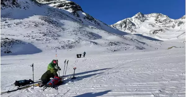
Eight teams, each led by an expert from Eurac Research, traveled the same routes on the ground to measure the snow’s depth with scaled rods and weigh the snow to determine its type. If examination of the data gathered demonstrates that the technology is trustworthy and the measurements agree with those made on the ground, it might then be mounted on satellites.
Researchers had been exchanging emails back and forth for weeks: “There is a possible window next week,” “Canceled: bad weather on the way,” and “We’ll try again as soon as high pressure returns.”. The announcement was followed by the phrase, “We have the go-ahead for tomorrow. The emails adopt a fresh tenor. Equipment checklists, updated equipment checklists, flight plans, and safety precautions for the nth time
“Until now, we’ve used satellite images to monitor snow, which measure direct properties like depth and density.”
Carlo Marin, a remote sensing engineer at Eurac Research.
On April 4, the first group departs at first light while carrying skis, ski skins, and backpacks. Soon after, a little Cessna takes off from the airport in Trento. Tech to be tested on board.
About 7 a.m., the first flight touched down in the valley, and the second at about 1 p.m. The Cessna flew over the area in a zigzag pattern for about 40 minutes during each flight, at a height of 5,000 meters. Having the same flight at various times of the day was crucial for the research team.
Carlo Marin, a remote sensing engineer at Eurac Research, explains that up until now, satellite images that measure direct properties like depth and density have been used to monitor snow conditions.
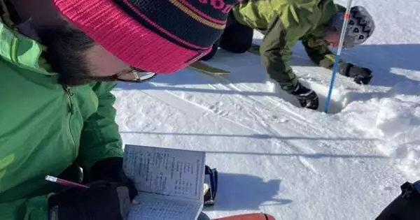
The findings of the seven measurements made at each point were noted by remote sensing engineer and test manager Carlo Marin. Riccardo Barella is in the background, checking the temperature in a tiny hole. To ensure that the results are as consistent as possible, the temperature is measured at two different depths (10 cm and 30 cm), always from the side that is not directly exposed to the sun. Credit: Eurac Research | Maurizio Gretter
“Instead, this method developed by the University of Milano-Bicocca measures the snow’s ability to breathe or the air’s ability to exchange heat with the snow. We can estimate characteristics like snow type and density based on this information. While the surface layer of snow is warmer during the warmer hours of the day due to higher temperatures and sunlight, the temperature is cooler during the early morning flight. According to how various snow types exchange heat with their surroundings, there is a correlation between temperature differences.
Additionally, the experimental sensor images indicate very high resolution.
22 people were stationed on the ground to measure the depth and weight of the snow at three-meter intervals as the small Cessna flew over 12 strips that were technically known as “transects.” We were able to gauge the snow’s density this way: wetter snow is heavier, while dryer, powderier, and finer snow is lighter.
Some research teams had easy access to lifts, but others had to trek for hours with skis, ski skins, and equipment-filled backpacks to reach remote locations like the Teufelsegg peak, which is located below the Weisskugel/Palla Bianca (3,738 m). In order to further validate the measurements from the ground, one team also included technicians who were carrying a sensor similar to the one that was mounted on the aircraft.
The research team will compare the measurement outcomes in the upcoming months in order to determine whether the technology is advanced enough to be mounted on a satellite and made operational.
In light of the climate crisis, which is making water a more valuable and scarce resource, carefully estimating the presence of snow, especially at high altitudes, will become increasingly important in determining the availability of water for the summer season and, as a result, provide support to those who have to manage this resource, says Marin.
Provided by Eurac Research


