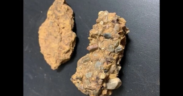
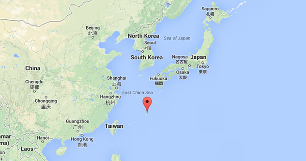
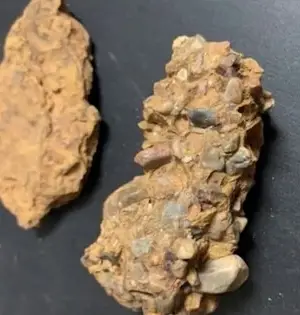
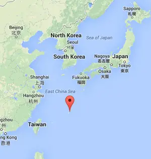
close

Geography

Geography

Miyako Islands’ Endemic Species’ Origins are explained by the Disappearing Island

Endemic species are those that can only be found in a certain geographic area and are not found anyplace else. They usually emerge as a result of a mix of geographical isolation and evolutionary processes. In the case of the Miyako Islands, their isolation from the rest of Japan and other surrounding landmasses has aided in the evolution of distinct species over time. Miyako Islands are home to a variety of native snakes and lizards. Scientists have long wondered how these creatures came to call these islands home. A group of academics reviewed the most recent geological and biological data
Geography

Researchers Find Reasons to Reconsider How Mountains are Built Below the Surface

According to a study conducted by Colorado State University, the explanations for how and why mountains arise are more deeply hidden than previously believed. “Mountain building is a fundamental process of how Earth behaves,” said Sean Gallen, lead author and CSU assistant professor of geosciences, “and this study suggests that we may not understand that as well as we thought we did.” In order to use landscapes to recreate lengthy histories of mountain construction in southern Italy, Gallen and his team developed new data sets and methodologies. Their novel approach yielded some “confounding” results, according to Gallen. One tectonic plate
Geography

Sources of CO2 from Aleutian-Alaska Arc volcanoes have been discovered through research

The Aleutian-Alaska Arc is a volcanic arc located in the Pacific Ring of Fire's northernmost region. It stretches over 3,000 kilometres from the Alaska Peninsula to the Aleutian Islands and is known for its dense concentration of active volcanoes. Scientific research has been conducted on these volcanoes in order to better understand their environmental impact, including the release of carbon dioxide (CO2) gas. Scientists have long wondered what happens to the organic and inorganic carbon that Earth's Pacific Plate transports into the planet's interior as it moves along the volcano-studded Ring of Fire. According to a new study, a significant
Geography

A Study explains Unusual Deformation in the World’s Largest Continental Rift

The East African Rift System is the world's largest continental rift. It runs over 6,000 kilometres (3,700 miles) from Ethiopia's Afar Triple Junction to Mozambique. The East African Rift System is a tectonic feature that is active and characterised by rift valleys, volcanic activity, and the formation of new crust. The African Superplume is responsible for the unusual deformations and rift-parallel seismic anisotropy observed beneath the East African Rift System, according to computer models. Continental rifting is characterised by a combination of stretching and breaking that extends deep into the Earth, according to geophysicist D. Sarah Stamps. Continental rifting involves
Geography

Significant Underwater Plateau Near the Solomon Islands is Younger and Eruption Was Longer Than Thought

According to recent research led by Oregon State University, the Ontong Java Plateau, an underwater volcanic plateau in the Pacific Ocean north of the Solomon Islands, is younger and its eruption lasted longer than previously believed. The results, which were just published in Science, also call into question long-held beliefs that the formation of the plateau, which is roughly the size of Alaska, was the reason for an oceanic black shale deposit around the world. “This type of shale is formed when there is very limited oxygen in the ocean. This layer was formed about 120 million years ago and
Geography

Satellite Signals Halfway Around the World are Disrupted by the Eruption of the Tonga Underwater Volcano

An equatorial plasma bubble (EPB), which might be caused by volcanic eruptions, could seriously interfere with satellite-based communications, according to research conducted by an international team using satellite and ground-based ionospheric measurements. Their findings were published in the journal Scientific Reports. The area of the Earth's upper atmosphere known as the ionosphere is where solar energy ionizes molecules and atoms, producing positively charged ions. The F-region, located 150 to 800 km above the Earth's surface, is the region with the largest concentration of ionized particles. Because it reflects and refracts radio waves used by satellite and GPS tracking systems back
Geography

Rising Temperatures have an Impact on Alaskan Rivers, and the Effects are Reverberating Across Indigenous Communities

According to recent research led by the University of Colorado Boulder, streamflow in Alaskan rivers is increasing throughout both the spring and fall seasons, owing mostly to rising air temperatures over the last 60 years. This increased volume of free-flowing water during the shoulder seasons is exacerbated by earlier snowmelt and thawing permafrost, both of which are being influenced by rising temperatures; all of which are influencing the formation and safety of Alaska river ice in winter, as well as the timing of when rivers “break up” in response to seasonal warming each spring. The findings are the result of
Geography

The World’s Largest Cumulative Logjam, Recently Discovered in the Arctic, has 3.4 Million Tons of Carbon

Throughout the Arctic, rivers transport fallen trees from forests to the ocean. As the river twists and turns, the logs can stack up, resulting in long-term carbon storage. A new study has mapped the largest known woody deposit, covering 51 square kilometers (20 square miles) of the Mackenzie River Delta in Nunavut, Canada, and calculated that the logs store about 3.4 million tons (about 3.1 million metric tons) of carbon. “To put that in perspective, that's about two and a half million car emissions for a year,” said Alicia Sendrowski, a research engineer who led the study while at Colorado
Geography

The 2022 Tongan Volcanic Explosion was the Largest Natural Explosion in Over a Century, According to a New Study

According to a new study led by scientists from the University of Miami Rosenstiel School of Marine, Atmospheric, and Earth Science and the Khaled bin Sultan Living Oceans Foundation, the 2022 eruption of an undersea volcano in Tonga was more powerful than the biggest nuclear detonation in the United States. The 15-megaton volcanic explosion from Hunga Tonga-Hunga Ha'apai, one of the largest natural explosions in more than a century, caused a mega-tsunami with waves up to 45 meters (148 feet) on Tonga's Tofua Island and 17 meters (56 feet) on Tongatapu, the country's most populated island. Rosenstiel School researchers created
Geography

According to a Study, Indigenous Territories and Protected Areas are Essential for Maintaining the Brazilian Amazon’s Forests

Time series satellite images from 2000 to 2021 were analyzed in a study led by researchers with the Center for Earth Observation and Modeling at the University of Oklahoma. The results showed the critical importance of Indigenous territories and protected areas in Brazilian Amazon forest conservation. The study's findings, which were recently published in Nature Sustainability, highlighted the detrimental effects of the government's newly weakened conservation laws. The Brazilian Amazon is home to the world's largest tropical forest and richest biodiversity. Since 2000, Indigenous territories and protected areas have increased substantially in the region, and by 2013; Indigenous territories and