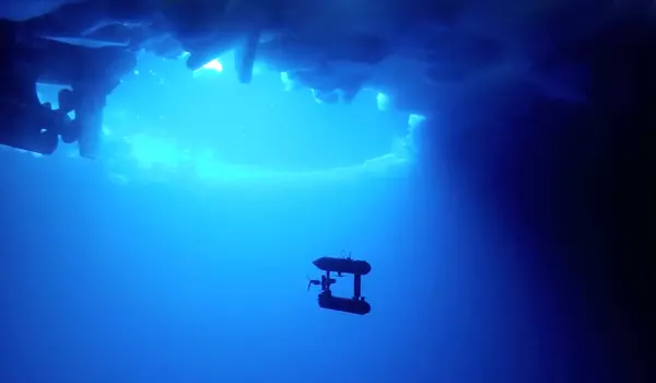
A US-New Zealand research team used an underwater robot called Icefin to get an unprecedented look inside a crevasse at Kamb Ice Stream, revealing more than a century of geological processes beneath the Antarctic ice. Cameras on the remotely operated Icefin underwater vehicle relayed a sudden change in scenery high in a narrow, seawater-filled crevasse at the base of Antarctica’s largest ice shelf.
Smooth, cloudy meteoric ice walls abruptly turned green and rougher in texture, morphing into salty marine ice. Nearly 1,900 feet above the surface of the Ross Ice Shelf, near where it meets the Kamb Ice Stream, a U.S.-New Zealand research team recognized the shift as evidence of “ice pumping,” a process never before directly observed in an ice shelf crevasse and critical to its stability.
“We were looking at ice that had just melted less than 100 feet below, flowed up into the crevasse, and then refrozen,” Justin Lawrence, visiting scholar at the Cornell Center for Astrophysics and Planetary Science, explained. “And then it just got weirder and weirder as we got higher up.”
The Icefin robot’s unprecedented look inside a crevasse, and observations revealing more than a century of geological processes beneath the ice shelf, are detailed in “Crevasse Refreezing and Signatures of Retreat Observed at Kamb Ice Stream Grounding Zone,” published in Nature Geoscience.
Antarctica is a complex system and it’s important to understand both ends of the spectrum – systems already undergoing rapid change as well as those quieter systems where future change poses a risk. Observing Kamb and Thwaites together helps us learn more.
Britney Schmidt
The paper describes the findings of a 2019 field campaign to the Kamb Ice Stream led by Christina Hulbe, professor at the University of Otago, and colleagues, which was funded by Antarctica New Zealand and other New Zealand research agencies. A research team led by Britney Schmidt, associate professor of astronomy and earth and atmospheric sciences at Cornell University, was able to join the expedition and deploy Icefin thanks to funding from NASA’s Astrobiology Program. Schmidt’s Planetary Habitability and Technology Lab, which began at the Georgia Institute of Technology, has been working on Icefin for nearly a decade.
When combined with recent research on the fast-changing Thwaites Glacier, which was explored by a second Icefin vehicle during the same season, the findings are expected to improve models of sea-level rise by providing the first high-resolution views of ice, ocean, and sea floor interactions at contrasting glacier systems on the West Antarctic Ice Sheet.
Thwaites is one of the continent’s most unstable glaciers because it is exposed to warm ocean currents. The Kamb Ice Stream has been frozen since the late 1800s, where the ocean is extremely cold. Kamb currently offsets some of western Antarctica’s ice loss, but reactivation could increase the region’s contribution to sea-level rise by 12%.

“Antarctica is a complex system and it’s important to understand both ends of the spectrum — systems already undergoing rapid change as well as those quieter systems where future change poses a risk,” Schmidt said. “Observing Kamb and Thwaites together helps us learn more.”
NASA funded the development of Icefin and the Kamb exploration in order to expand ocean exploration beyond Earth. Marine ice like that found in the crevasse could be an analog for conditions on Jupiter’s icy moon Europa, which is the target of NASA’s Europa Clipper orbital mission, which is scheduled to launch in 2024. Later lander missions could look directly for microbial life in the ice.
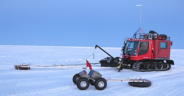
Icefin transports a full suite of oceanographic instruments on a modular frame that measures more than 12 feet long and less than 10 inches in diameter. It was lowered on a tether through a borehole drilled with hot water through the ice shelf by the New Zealand team.
Icefin mapped five crevasses and the sea floor during three dives spanning more than three miles near the grounding zone where Kamb transitions to the floating Ross shelf, while recording water conditions such as temperature, pressure, and salinity.
The team noticed a variety of ice features that provide useful information about water mixing and melt rates. They included golf ball-like dimples, ripples, vertical runnels, and the “weirder” formations near the crevasse’s top: globs of ice and finger-like brinicle-like protrusions.
According to the researchers, the ice pumping observed in the crevasse likely contributes to the relative stability of the Ross Ice Shelf, the world’s largest by area, the size of France, compared to Thwaites Glacier.
“It’s a way these big ice shelves can protect and heal themselves,” said Peter Washam, a polar oceanographer on the Icefin science team and the paper’s second author. “A lot of the melting that happens deep near the grounding line, that water then refreezes and accretes onto the bottom of the ice as marine ice.”
Icefin mapped parallel sets of ridges on the sea floor, which the researchers believe are impressions left behind by ice shelf crevasses – and a record of 150 years of activity since the Kamb stream became stagnant. The ice shelf thinned as its grounding line receded, causing the crevasses to lift away. The slow movement of the ice over time shifted the crevasses seaward of the ridges.
“We can look at those sea floor features and directly connect them to what we saw on the ice base,” said Lawrence, now a program manager and planetary scientist at Honeybee Robotics. “In a sense, we can rewind the process.”


