Hurricane Harvey stalled after making landfall over coastal Texas in 2017, pouring down record rainfall, flooding communities, and becoming one of the wettest and most destructive storms in US history. According to Penn State scientists, a new technique based on readily available data reduces forecast errors and could improve track, intensity, and rainfall forecasts for future storms like Hurricane Harvey.
“Our research shows that there are opportunities for producing more accurate forecasts for tropical cyclones using available but underutilized data,” said Yunji Zhang, assistant research professor in Penn State’s Department of Meteorology and Atmospheric Science. “This could lead to better warnings and preparedness for tropical cyclone-related hazards in the future.”
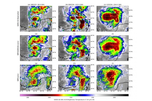
Using Hurricane Harvey as a case study, the scientists found that incorporating microwave data collected by low-Earth orbiting satellites into existing computer weather forecast models improved forecasting storm track, intensity, and rainfall.
“Over the ocean, we don’t have other kinds of observations beneath the cloud tops to tell us where the eyewalls are, where the strongest convections are, and how many rain or snow particles are in those regions, except for occasional reconnaissance aircraft that fly into some of the hurricanes,” Zhang explained. “This is critical for future forecasts of how intense storms will be and how much rainfall hurricanes will bring.”
Our research shows that there are opportunities for producing more accurate forecasts for tropical cyclones using available but underutilized data. This could lead to better warnings and preparedness for tropical cyclone-related hazards in the future.
Yunji Zhang
The study builds on the team’s previous work, which improved hurricane forecasts by using data assimilation, a statistical method that aims to paint the most accurate picture of current weather conditions, which is important because even minor changes in the atmosphere can lead to large differences in forecasts over time.
Scientists from Penn State’s Center for Advanced Data Assimilation and Predictability Techniques previously assimilated infrared brightness temperature data from the GOES-16 geostationary operational environmental satellite. Brightness temperatures indicate how much radiation is emitted by objects on Earth and in the atmosphere, and the researchers used infrared brightness temperatures at various frequencies to paint a more accurate picture of atmospheric water vapor and cloud formation.
However, infrared sensors can only see what is happening at the cloud tops. According to the scientists, microwave sensors can see an entire vertical column, providing new insight into what happens beneath clouds after storms form.
“This is especially important as a hurricane matures in later stages of development, when there are pronounced and coherent cloud structures and you can’t see what’s going on underneath them,” Zhang said. “Hurricanes are most dangerous during this time because they are very strong and sometimes already approaching landfall and threatening people. That is when microwave data will provide the most useful information.”
Combining assimilated infrared and microwave data reduced forecast errors in track, rapid intensification and peak intensity compared to infrared radiation alone for Hurricane Harvey, the researchers reported in the journal Geophysical Research Letters. They said assimilating both sets of data resulted in a 24-hour increase in forecast lead-time for the rapid intensification of the storm, a critical time when some storms quickly gain strength.
According to the scientists, incorporating the microwave data resulted in a better understanding of the amount of water particles in the storm as well as more accurate rainfall totals for Harvey.
“Rainfall forecasting is critical for preparing the public for hazards and evacuations,” Zhang explained. “If we have a better understanding of how many rainfall particles are in the storm, we can make more accurate forecasts of how much rain will fall. We will have more advanced guidance on how people should react based on this.”
More work is needed, according to the scientists, to improve the model’s microphysics and simulate water and ice particles more realistically. This research is based on the work of former Penn State Distinguished Professor Fuqing Zhang, who led the project until his untimely death in July 2019.
“When our dear friend and colleague Fuqing Zhang passed away, the thread of ideas that had been weaving together our ongoing combined infrared and microwave radiance data assimilation experiments unraveled,” said Eugene Clothiaux, professor of meteorology and atmospheric science and a co-author of the paper. “We worked together for a long time to reassemble the thread as best we could.”