Researchers investigated a deep intraslab earthquake that happened on March 4, 2021, off the northeastern corner of New Zealand’s North Island using a unique finite-fault inversion method and seismometer data from around the world. This imaging revealed complex rupture geometry, such as shallow faulting with trench-perpendicular extension and unusual deep faulting with trench-parallel compression, which could be caused by seamount subduction and/or the transition between the Kermedec Trench and the Hikurangi Margin, which has different thicknesses of subducting oceanic crust.
The 2021 Kermadec Islands earthquakes were a series of 8.1 and 7.4 magnitude earthquakes that occurred on March 4, 2021, at 19:28:31 UTC. The epicenters were located in the Kermadec Islands, which are part of New Zealand’s outer islands, southeast of Raoul Island. The major 8.1 magnitude earthquake was preceded by a 7.4 magnitude foreshock and followed by a 6.1 magnitude aftershock. A minor, unrelated magnitude 7.3 earthquake happened several hours before the main quakes off the coast of New Zealand’s North Island, around 900 kilometers to the south. There have been thousands of aftershocks as of January 2022, with more than a dozen of them topping magnitude 6.
The world’s greatest and most devastating earthquakes occur in subduction zones, where a slab of the oceanic plate is forced beneath another tectonic plate and down into the mantle. Understanding and planning for big earthquakes require reconstructing the shape and stress conditions of sub-ducted slabs at subduction zones. However, the enormous depths of these slabs make this difficult; seismologists rely mostly on the rare windows into these deeply buried slabs offered by the uncommon but powerful earthquakes, known as intra-slab earthquakes, that occur within them.
The 2021 East Cape earthquake demonstrated a complex rupture mechanism, most likely due to its placement at the boundary between the Kermadec Trench to the north and the Hikurangi Margin to the south. We employed an unique finite-fault inversion technique that requires no prior knowledge of the area’s faults to analyze the geometry of the stress field and earthquake rupture process.
Assistant Professor Ryo Okuwaki
A research team led by the University of Tsukuba used seismic data generated by a magnitude 7.3 earthquake that occurred off the north-easternmost tip of New Zealand’s North Island on March 4, 2021, and was detected by seismometers around the world, in a new study published in Geophysical Research Letters, to investigate the particularly unusual geometry and stress states of the subducted slab deep below the surface in this region.
“The 2021 East Cape earthquake demonstrated a complex rupture mechanism, most likely due to its placement at the boundary between the Kermadec Trench to the north and the Hikurangi Margin to the south,” explains study main author Assistant Professor Ryo Okuwaki. “We employed an unique finite-fault inversion technique that requires no prior knowledge of the area’s faults to analyze the geometry of the stress field and earthquake rupture process.”
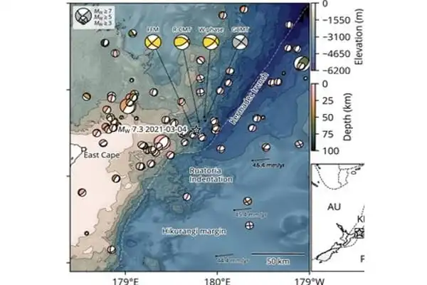
This analysis uncovered a number of rupture occurrences caused by both compression and extension in the subsurface at various depths. These episodes included a shallow (~30 km) rupture caused by extension perpendicular to the trench, which is typical of a subduction zone. However, the deep (~70 km) rupture occurred with compression parallel to the subduction trench, which was unexpected.
The Kermadec-Tonga subduction zone spans east of the Kermadec Islands, separating the Australian and Pacific plates. The denser Pacific Plate subducts or dives beneath the less dense Australian Plate at this convergent border.
“Two alternative or interconnected reasons may explain the distinctive rupture geometry of the 2021 East Cape earthquake,” reveals senior scientist Professor Yuji Yagi. “First, subduction of a seamount or multiple seamounts with the subducted slab could contort the slab and cause local changes in the stress field; second, the transition from the Kermadec Trench to the Hikurangi Margin, where the subducted oceanic crust is significantly thicker, could create the local conditions responsible for the unusual faulting pattern.”
Because deep intraslab earthquakes are uncommon in this location, distinguishing between these two hypotheses is now difficult; however, both mechanisms may have played substantial roles in constructing the complex stress pattern shown by the East Cape earthquake. Future earthquakes off New Zealand’s northeast coast could offer more insight on this profound tectonic puzzle.
According to GeoNet, the mainshock produced more than 300 landslides on Raoul Island’s high forest cliffs and jagged coastal cliffs. The most significant slide occurred at Pills Beach, where around 400 meters of coastal cliffs crumbled, forming a column of debris in the water. Raoul Island suffered some structural damage. However there were no casualties as the island was uninhabited at the time due to the COVID-19 pandemic.


