MBARI researchers and collaborators have published the first study to show how the thawing of permafrost, which is submerged underwater at the Arctic Ocean’s edge, is changing the seafloor. On March 14, 2022, the study was published in the Proceedings of the National Academy of Sciences.
Many peer-reviewed research have found that thawing permafrost generates unstable land, which has a negative impact on vital Arctic infrastructures like roads, train lines, buildings, and airports. Repairing this infrastructure is costly, and the consequences and costs are anticipated to rise in the future.
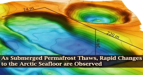
MBARI researchers and collaborators discovered that thawing permafrost is causing substantial changes to the bottom using modern underwater mapping technologies.
Deep sinkholes have formed in some regions, some larger than a city block of six-story buildings. Pingos, or ice-filled hills, have emerged from the seafloor in various regions.
“We know that big changes are happening across the Arctic landscape, but this is the first time we’ve been able to deploy technology to see that changes are happening offshore too,” said Charlie Paull, a geologist at MBARI and one of the lead authors of the study.
“This groundbreaking research has revealed how the thawing of submarine permafrost can be detected, and then monitored once baselines are established.”
This research was made possible through international collaboration over the past decade that has provided access to modern marine research platforms such as MBARI’s autonomous robotic technology and icebreakers operated by the Canadian Coast Guard and the Korean Polar Research Institute.
Scott Dallimore
While human-caused climate change has contributed to the degradation of terrestrial Arctic permafrost, the changes the research team has documented on the seafloor associated with submarine permafrost are the result of much older, slower climatic shifts related to our emergence from the last ice age. For thousands of years, similar changes appear to have occurred at the seaward edge of the old permafrost.
“There isn’t a lot of long-term data for the seafloor temperature in this region, but the data we do have aren’t showing a warming trend. The changes to seafloor terrain are instead being driven by heat carried in slowly moving groundwater systems,” explained Paull.
“This research was made possible through international collaboration over the past decade that has provided access to modern marine research platforms such as MBARI’s autonomous robotic technology and icebreakers operated by the Canadian Coast Guard and the Korean Polar Research Institute,” said Scott Dallimore, a research scientist with the Geological Survey of Canada, Natural Resources Canada, who led the study with Paull.
“The Government of Canada and the Inuvialuit people who live on the coast of the Beaufort Sea highly value this research as the complex processes described have implications for the assessment of geohazards, creation of unique marine habitat, and our understanding of biogeochemical processes.”
Background
As sea ice retreats due to climate change, scientists have just lately gained access to the Canadian Beaufort Sea, a remote part of the Arctic.
Since 2003, MBARI has collaborated with the Geological Survey of Canada, the Department of Fisheries and Oceans Canada, and, since 2013, the Korean Polar Research Institute to research the seafloor of the Canadian Beaufort Sea.
MBARI mapped the bathymetry of the seafloor down to a resolution of a one-meter square grid, or roughly the size of a dinner table, using autonomous underwater vehicles (AUVs) and ship-based sonar.
This summer, Paull and his research team will return to the Arctic aboard the R/V Araon, a Korean icebreaker. This expedition, which will include MBARI’s long-time Canadian and Korean collaborators as well as the US Naval Research Laboratory, will help us enhance our understanding of undersea permafrost deterioration.
MBARI’s two AUVs will map the seafloor in incredible detail, and MBARI’s MiniROV, a portable remotely operated vehicle, will allow for additional exploration and sampling in addition to the mapping studies.
The David and Lucile Packard Foundation, the Geological Survey of Canada, Fisheries and Oceans Canada, and the Korean Ministry of Ocean and Fisheries (KIMST grant No. 1525011795) all contributed to this project.


